We're committed to helping you
The Missing Years - Chapter Eighteen
Chapter 18: Exploring a New World of Parks, 1917
On September 4, 1917, I boarded a train for Los Angeles to meet Douglas White, a railroad official with whom I had agreed to visit Mukuntuweap National Monument in Utah. No Interior Department official had ever seen the place. I was deeply concerned about our national monuments, the forgotten orphans of the service. Only about $120 a year was allocated to each monument, $1 a month for most of their custodians.
The monuments were so fascinating, with such diversity. My love of both history and natural beauty made their varied characteristics especially interesting, and I wanted to learn more about them. Much as I hated leaving my Grace behind in Berkeley, Albright finances simply couldn't stretch to take her with me. We agreed she would join me in Denver for the return to Washington.
In Los Angeles White met me and rushed me over to a train already overdue to leave. He had been able to hold it, as he was the general passenger traffic manager of the Los Angeles and Salt Lake Railroad, in those days known simply as the Salt Lake Line. A few years later it was sold to the Union Pacific.
The next morning we alighted in Lund, Utah, and climbed into a vehicle that didn't look like it could even start, much less take us across to the monument. Fortunately, it didn't have to because at Cedar City we were met by two brothers, Gronway and Chauncey Parry, who operated an "auto service" to Mukuntuweap.
Word had preceded us that Horace Albright, "a special agent of Secretary of the Interior Franklin K. Lane," was to inspect the "scenic Mormon territories" and would address the population of Cedar City. No one had bothered to mention this to me until the Parry brothers tipped me off as we rode into the center of town and saw the waiting crowd. From the elevation of the back seat of the touring car, I gave them a rousing, impromptu speech about the National Park Service and the beauties of Utah (which I hadn't yet seen).
Joined by former state senator Henry Lunt and R. A. Thorley, we sped off toward the east in a fine eight-passenger car driven by Chauncey Parry. In Rockville Bishop David Herschi of the Mormon Church was added to our group, as I had been warned not to go into Mormon territory without a "native guide."
I had certainly picked marvelous companions for this trip to Mukuntuweap. Lunt and Thorley were veritable encyclopedias about the region. Douglas White was a clever storyteller, a great mimic, and something of a singer, and he kept us entertained every minute. Best of all, he had spent a lot of time at the monument and knew it well. And Herschi was wonderful, a joyful soul whose ebullient voice joined White in chorus after chorus of rousing Mormon hymns. Even my off-key baritone chimed when we came to "Oh, Come All Ye Saints."
It was just as well there was such diversion because the hundred or so miles to Mukuntuweap were a real test of physical fortitude. We spent the next uncounted hours bouncing and crashing over some of the worse roads I had ever experienced. The state of Utah obviously didn't give a tinker's dam about "Dixie," the southern part of the state, for convict labor had been used to make these so-called roads. Those men probably took out their hate and frustration on the projects. I fervently prayed that the pathetic appropriation of $10,000 that Utah's Senator Reed Smoot had wrung out of Congress for the monument's roads had been spent on a different set of workers.
We finally cruised into the little town of Springdale. Standing out in the boiling hot sun, waiting patiently to greet us, was Walter Ruesch. He was there to direct us to his home, where refreshments were waiting. I'll always remember the picture that greeted us at Ruesch's place. Framed in the doorway of this rude, rustic house was a serenely beautiful woman holding a small child, the epitome of pioneer grace. She was Marilla Ruesch, an unforgettable lady who was a key element in her husband's future success in the Park Service.
I guess you could call Ruesch somewhat of an employee of the National Park Service because he took care of some equipment the government had left here when the road work was finished. I questioned Bishop Herschi about him and suggested that I could hire him as a custodian of the monument, though I was only able to pay him a negligible salary.
The bishop replied: "Well, you wouldn't want this man. He has a terrible habit. You really couldn't have him around your tourists. Ever since he was a little boy, we have tried to do something with him, but we have never been able to break him of it, and, as the years pass, he gets worse."
Several times I asked him, "Why? What's the matter?" No answer.
Finally he gave in and answered: "I guess I'd better tell you what this poor man's problem is and why you just can't have him around people. The awful fact is that he swears. He just doesn't say one bad word. He just plain swears like it was the devil himself talking."
In the next few days I got to know this very pleasant, polite gentleman. He took me around to see the government equipment he was caring for, an old block and tackle. He told me the person from whom it had been rented had charged the government way too much for its use and voiced his opinion of the man. Although he spoke quietly, he not only used all the swear words I had ever heard, but he cooked up some of his own. He was certainly a full-flamed fellow if ever there was one. Actually he sounded a lot like my old grandfather, who proclaimed that it was all right to swear profusely and graphically because the English language was so darned inexpressive.
Later on Bishop Herschi confessed he'd overheard my conversation with Ruesch and said: "You see what I told you.The man is impossible."
But I liked Ruesch and admired his devotion to the monument. I went ahead and hired him on a day-to-day basis right then, later making him a full custodian and finally the superintendent of Zion National Park when it had evolved from Mukuntuweap National Monument.
There were a few difficulties with him, like the time the president of the Union Pacific Railroad and other dignitaries visited. They were a pretty high and mighty group, quite patronizing to Ruesch, but he retained a dignified, gentlemanly appearance throughout the three- or four-day visit. As they finally drove off, Ruesch turned to a ranger and proclaimed in a fine, bellowing voice, "Hell, the sons-of-bitches are gone, but I think the bastards enjoyed themselves."
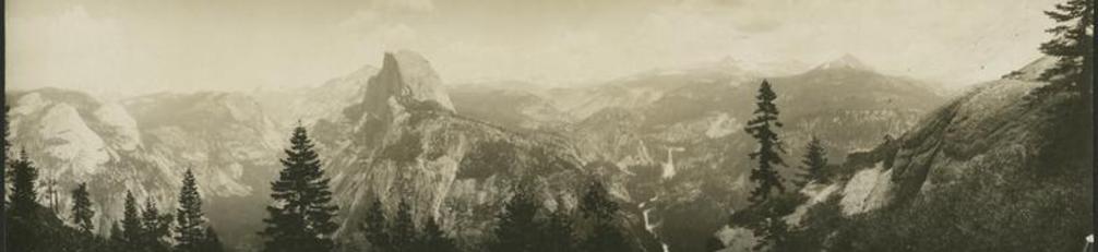
Now beholding Mukuntuweap and the so-called Little Zion Canyon for the first time, I was surprised, excited, and thrilled. More than that, I was just plain stunned. I had no concept of the staggering beauty I beheld. Local Utah people said that Yosemite was a Zion without color. But this didn't faintly prepare me for the reality of the towering rock walls, splashed with brilliant hues of tans and reds interspersed with whites. The great towers, temples, spires, and peaks appeared unearthly as they encircled the narrow, lush gorge cut by the sparkling Virgin River. I remember exclaiming, "Oh, it is so like Yosemite."
Someone immediately corrected me: "No, Little Zion was not created by glaciers. It was created not too many millions of years ago by the water of this river carving out the soft sandstone."
Whatever created this marvel of natural splendor, it was love at first sight for me. Ever after, I claimed this national park (along with Grand Teton) as mine. From day one it was a personal crusade to mold it from a little national monument into a great national park.
I was excited and enthused by the grandeur of Little Zion, as I began to call it. I always preferred local names, especially native Indian ones, for natural wonders, but Mukuntuweap was a problem. It was an Indian name for the river. John Wesley Powell had translated the name as "straight river." I felt "Mukuntuweap" was too difficult to pronounce and really tough to spell.
I sounded out the local people and found they all used just the one word "Zion," which to Mormons meant "heaven" or a "heavenly place." That sounded about right to me, so I decided that when I returned to Washington and pressed for national park status, I would use that too. It also seemed to fit because the Mormons, who had settled here around 1860, had named many of the landmarks of the valley with religious themes, feeling they were like temples to God, such as Angels Landing, West Temple, and the Three Patriarchs.
During the few days I was at Zion, White and I covered an enormous amount of territory, often with Ruesch and other local men. We took horses to get to the top of the great cliffs, exploring the high country and studying the canyon from three thousand feet above to work out plans for extending the borders of the monument. We tramped on foot the full length of Little Zion Canyon to the very end of the Narrows. Here lay an incredible extension where outstretched arms can almost touch both sides of the overhanging cliffs and flowers drip down the walls with the seeping waters. We stood at dusk watching the last rays of the sun glow on the glistening walls of the Great White Throne. Truly a spiritual experience.
There were practical decisions to be made. Although few people except the locals visited here, I knew that as soon as publicity to create a national park was spread in newspapers and magazines, with accompanying pictures to show its beauty, tourists would begin to come, probably in droves. So the facilities in the area had to be taken into consideration.
It was incredible, but the government had actually spent ten thousand dollars on roads here. No complaints about that. Then there were the concessions. Up to this time, there had been no proper accommodations short of Cedar City, but White assured me he had a gentleman who was the answer to that problem. He introduced me to an old man, W. W. Wylie, who had constructed a tourist tent camp in Zion Canyon.
Well, I was amazed. I had never met him before but knew all about him, as he had originated the permanent camp system in Yellowstone, selling out there years before. His so-called Wylie Way was so efficient and popular that it was copied by the Currys in Yosemite. I knew of his integrity, honesty, and knowledge of national park standards. His camp here looked neat and clean. The Interior Department had already granted him a five-year lease for the camp and added the transportation franchise too.
I assured Wylie that I approved of his camp operations but asked him to submit future plans for these as well as how he was going to set up his system to bring visitors from the rail line. As there had been only three hundred tourists to the monument that season, there really hadn't been any test of how operations would go when large crowds poured in. However, I trusted Wylie's experience in Yellowstone and felt he would make a valuable contribution to solving concession problems.
I hated to leave Zion. I deeply regretted not being able to explore the other two canyons of the region and the ancient Indian cliff dwellings. I hadn't even known they existed until my visit. So again this fit my "perfect park," a combination of scenic wonders and historic sites.
But I had to push on with my inspection trip. Saying good-bye to the kindly Mormon people, I assured them that as soon as I got back to Washington I would go full steam ahead to enlarge this monument and have it made a national park. And so I did. President Wilson changed its status to Zion National Monument on March 18, 1918, and on November 19, 1919, it became a greatly enlarged national park.
In Salt Lake City Doug White and I were busy with a sightseeing tour for army draftees and then a meeting with Utah's Governor Simon Bamberger concerning access roads to Zion. In his heavily accented voice, he shouted, "I build no more roads to rocks!"
On the night of September 1, 1917, I met Frank Wadleigh, passenger traffic manager of the Denver and Rio Grande Railroad, and climbed aboard a special car attached to a regular D & RG passenger train bound for Denver. It was the beginning of one of the most memorable trips I ever had, a complete tour of this railroad, narrow and broad gauge. The purpose was to explore Colorado, our present holdings, and possible future acquisitions for the park system.
We alighted from our train at Grand Junction, Colorado, in time to see the sun casting its first light over the lush valley watered by the Colorado and Gunnison Rivers. Wadleigh had a car and driver waiting for us, and after a hearty breakfast we drove to the west a few miles to Colorado National Monument to meet John Otto, the custodian.
Checking out this national monument had been one of the primary reasons for this trip. I was deeply interested in the condition of these orphans of the Park Service. I knew I didn't have time to hit the string in Utah and the Southwest, but I felt I could get a grip on the problems of the monuments if I inspected just one. This, of course, didn't count Mukuntuweap. In my mind it was already a national park.
To illustrate the difficult situation in the monuments, here is a quote from Robert Marshall's 1916 annual report to the secretary of the interior: "During the past session, Congress appropriated $3,500 for preservation, development, administration, and protection of the national monuments." In other words, the $3,500 had to be divided between the Interior Department's twenty-one monuments and had to cover everything, including salaries for the custodians.
Colorado National Monument was a fine example for me to study. I already knew John Otto from the Berkeley meeting. The area was visited by more tourists than most monuments and was kept in remarkable shape considering that only this one man was responsible for its total care. I was frankly astonished at the size of Colorado Monument, the height to which the plateau rose (nearly two thousand feet above the GrandValley), the deep canyons, the colorful vertical cliffs and soaring monoliths, the comparison of sparse desert and lush areas at springs where water seeped through rocks to form gardens of brilliant flowers.
John Otto was a marvelous guide and knew every inch of his monument, which he tended like a personal kingdom. His pathetic pay of one dollar a month from the government couldn't even feed him, but somehow he had managed to fence in most of his twenty thousand acres to protect the deer, bighorn sheep, and birds. He had also constructed trails and a nice entranceway to the monument. He had inspired the local community to chip in to further his work. His first trail, the Corkscrew, started with $154 donated by subscribers to the local newspaper, just enough money to buy blasting powder and tools. Otto provided the labor. His devotion and magnificent work were most impressive, and I promised I'd somehow help him with supplies and future appropriations.
I told him there was one thing I would surely do when I got back to Washington. A township survey had showed that the monument did not include all the lofty monoliths intended by the original proclamation in 1911. In Washington I went to a great conservationist and friend of the parks, Congressman Edward Taylor of Colorado. He drew up a proposal to add these 3,500 acres adjacent to the south and west boundaries. It still took years before Otto's dream became reality, years after he had left his monument. That's the way things went for the national monuments, as Congress simply ignored them.
That morning in August 1917 at Colorado with John Otto was an experience and a lesson I never forgot. Otto's integrity, his love and selfless devotion to the land placed in his care, and his faith in our service and his country were a singular inspiration to me. The same held true for other custodians, such as Walter Ruesch, Evan Vogt, John Wetherill, Zeke Johnson, and others. They devoted their time and resources to the protection of their monuments, with little recompense, praise, or recognition.
Later, when I became director of the National Park Service, I was most aggressive on behalf of our existing monuments and the creation of new ones, as well as in obtaining the transfer to the National Park Service of all those held by the War Department and the Forest Service in the Agriculture Department.
Wadleigh kept nudging me until I woke up to the fact that our train would shortly be leaving Grand Junction. We boarded a magnificent private car tacked on to the end of a through train to Denver, the broadgauge Royal Gorge Route. The car was quite a sight, with walls paneled in exotic grained woods, etched glass lighting, plush upholstered furniture, and touches of gilt glittering throughout. It was complete with a kitchen and several uniformed men to serve us.We lacked nothing that the nineteenth- century nabobs enjoyed. Lounging in deeply comfortable swiveling armchairs and sipping iced lemonade, I was entertained by Wadleigh alternately reading from a stack of railroad booklets and telling marvelous anecdotes about the wild and wooly history of the line and the areas through which we were traveling.
I was awed by the spectacular mountain country unfolding along our route paralleling the Colorado River to Glenwood Springs, with its impressive resort hotels. The next eye-opener was the climb up famed Tennessee Pass through a towering mass of mountains to Leadville, still a booming mining town. Here we took a quick tour on foot in near blizzard conditions. Back on the train, we made a descent along the Arkansas River to Salida, where we were joined by John Steele of the Denver Tourist Bureau.
The next morning our party boarded another private car attached to a narrowgauge train and headed west. At fast it was a roller-coaster adventure, steep climbs up a pass and then down the other side on twisting tracks and muleshoe bends (narrow gauge for horseshoe). The last stretch to Montrose was one hundred miles of the Gunnison River Valley.
The day passed quickly as we chugged along through the Gunnison Valley, about one hundred miles from the west side of the pass at Sargent to Montrose. Shortly after leaving the town of Gunnison, several other narrow-gauge lines branched off to the north, and our line plunged into the Black Canyon of the Gunnison. Between Sapinero and Cimarron we rolled on a downward slope on the north side of the river through the depths of this awesome canyon. Our rails skirted the roaring torrent of the river, hugging the almost 4,000-foot perpendicular cliffs. The midnightcolored rocks above seemed dangerously insecure. The narrowness and depth of the canyon walls caused a shadowy twilight darkness at noon. The whole effect was eerie.
There was one startling sight along the walls of the canyon, a rock tower. It was named the Curecanti Needle, a solitary spear standing out like a finger pointing to the sky. It was the symbol or herald used by the D & RG as their logo for some time. Sadly, it has ended up halfsubmerged, a result of damming the Gunnison years later.
At Montrose, after a night in a hotel, Wadleigh had a car and driver waiting to take us out to see the Black Canyon of the Gunnison, from the top this time. The sorry dirt road from Montrose carried us about fifteen miles to near the rim of the canyon. We hiked out to the dizzy edge and then followed it along for miles.
What an amazingly different impression we had from the rim! The drop of a half a mile to the river was stupendous. The cliffs, which had seemed gray and threatening from below, now appeared striped and, in some places, quite colorful. The turgid, restless river was now a cool green ribbon.
Wadleigh and Steele talked excitedly about the tourist attraction this area could become. When they asked my opinion, all I could think of was a sentence in the Hayden Survey atlas of 1877: "There is nothing in America that equals the Grand Canyon of the Gunnison." Having seen the Grand Canyon of the Colorado, as well as other impressive clefts in the earth, I still was overwhelmed by the stark, prehistoric intensity of this one.
"By God, it'd make a magnificent national monument or even a national park," I said. Then I added, "And I swear it will be if I have anything to say about it." As director of the Park Service, one of the last things I asked President Herbert Hoover to do before he left office was to proclaim the Black Canyon of the Gunnison a national monument. It was created on March 2, 1933.
The following morning, we three again boarded Wadleigh's car on a different narrow gauge bound for Mesa Verde National Park. The country we passed through displayed deep valleys, steep passes, rushing rivers, railroad centers, and rough mining towns, including Ouray and Telluride. There was a peculiar remoteness to the landscape, growing stronger as we headed south toward Mancos.
At Mancos we were met by Supervisor Thomas Rickner of Mesa Verde, who was waiting in a large touring car. After packing our bags on the running board racks, we climbed in and were off for the park.
Within minutes, I was disillusioned as we started up a misnomer called "the scenic highway to the park." Highway? This twenty-mile stretch was one of the most disreputable, dangerous, fearsome bits of slippery, rutted miseries I ever had the misfortune to travel. It scared me even to think that the United States government had the nerve to offer this as an approach to a national park. My imagination got the best of me as I visualized the publicity arising from tourists slipping off hairpin turns and plunging to their deaths from the cliffs. Despite doubts that I or anyone else could ever reach the mesa above, we actually did crawl onto the beautiful green tableland and proceed to our lodging near the overlook to Spruce Tree House.
I had met Rickner before but had never had much of a chance to talk to him, get to know how he ticked. That frightening ride up to the mesa gave me a pretty clear readout on the man. He had been a professor—of what I can't remember, but it certainly wasn't in the field in which he was associated at Mesa Verde. This man didn't know archaeology or anything else about his national park.
In the few days I was there, I found it was being robbed blind. Digging and stealing ancient artifacts was a common occurrence, almost unpoliced and unpunished. When I got back to Washington, I launched an investigation and later found out that Rickner's son-in-law was one of the worst offenders, a leader of a band of surreptitious "midnight diggers." However, the evidence appeared to clear Rickner and his daughter, who apparently had no knowledge of her husband's activities.
At Spruce Tree Camp we got out of the car to glimpse our first cliff dwelling. This first view of the ruins was worth all the white knuckles and gray hair of the approach ride. The sun spotlighted the ancient complex called Spruce Tree House with what the locals called a "colorado" glow—the Spanish word for red. It was ethereal. The size, complexity, and condition of Spruce Tree astonished me and so quickened my interest that I proposed we have a look all around the park.
"Not possible," snapped Rickner. "First of all it's entirely too late in the afternoon. Couldn't possibly see more than a glimpse of this huge layout. Secondly, you may not know that we have only one auto road; its destination is Chapin Mesa. Otherwise we walk or ride a horse." I felt chagrined, sheepishly admitting to myself that I not studied enough about this park before I opened my mouth and showed my ignorance.
So we piled back into the car and drove a few miles to the very southern edge of the park on what Rickner had called "a road." This was not just a matter of a surface for autos. When you saw ones like these in Mesa Verde, it came down to protection of life and limbs for tourists visiting our "wonderlands." I had my camera with me and took a few pictures of these ruts. Illustration was the best way to convince our budget-minded, usually stingy congressmen how desperately the Park Service needed appropriations.
When the road came to an end, we walked up to Sun Temple, excavated only two years before by the famous archaeologist Jesse Walter Fewkes. Although hundreds of cliff dwellings, hidden away in almost inaccessible alcoves, had been discovered and many explored, there had never been evidence of manmade structures on the surface top of the mesa. Fewkes became interested in a great mound of earth near the edge of Chapin Mesa almost directly across the canyon from Cliff Palace, the largest cliff dwelling in the park. It had a depressed, circular center covered by trees and shrubs.When it was excavated, he discovered a huge, D-shaped building, undoubtedly a religious center, for it had no sign of living quarters. It was stunning. Even the ruins, located on the great promontory and imposing in size, over one thousand feet of walls, were awesome. Imagine what a sight it must have been to those living in the surrounding cliff villages when it was in pristine condition.
The panoramic view from about 8,500 feet elevation (or 2,000 above the Montezuma and Mancos Valleys) was breathtaking. You could see forever. To the southwest lay the Four Corners region, the only place in America where four states, Utah, Arizona, New Mexico, and Colorado, joined at right angles. The Abajo and La Sal mountains could be seen in distant Utah, while the great Sleeping Ute Mountain appeared to hug the Mesa Verde. To the north we could see the towering, snow-capped La Plata Range of the Rockies, to the south the Chuskas, and to the east dim Sangre de Cristos. Rivers weaving through the valleys, even the great monolith of Shiprock, seemed like miniatures from our promontory.
Mesa Verde was true to its name, a rich verdant green, cut by the deep canyons holding the ancient cities tight against their walls. The pristine, awesome beauty of the Southwest lay before us like a great painting by God.
As we walked around to the east, the beauty of Sun Temple was dwarfed by our first sight of the majesty of Cliff Palace, below and across from us on the east face of Cliff Canyon. From that distance, it appeared to be a westward-facing small city floating on perpendicular walls, with its stone structures impressive, well formed, and seemingly intact. The golden glow cast by the setting sun made it ethereal, unearthly. My imagination gave me the sensation of looking through a veil of light to people still alive in their world of hundreds of years ago. Here my fascination for these Anasazi, or ancient ones, was born, and so it has always remained.
Back at the "village," or Spruce Tree Camp, where we were to spend the night, we gratefully ate a hearty dinner. Collapsing after an especially memorable day, we rolled onto cots in our tents. However, it wasn't a particularly restful night. A terrific storm rolled in with thunder, lightning, and torrents of rain. The tent proved to be adequate, but the thought of lightning striking all around this wooded area made me pretty uneasy.
It was still dark when I woke up and decided to see the cliff ruins of Spruce Tree House by dawn. I threw on some clothes. Lots of them. It was mighty cold at 8,500 feet. As I came out of my tent, Steele called from his adjacent tent, "Hey, where ya going? Wait for me." We two were about to set off down a rough, winding path to the "village" of 114 rooms deep in the canyon when a young Navajo stopped us and asked where we were going. When he learned what we intended to do, he immediately warned us not to go alone and volunteered to guide us to Spruce Tree House. It was a good thing. Although the storm had passed, the rain had played havoc with the trail. It was a tough scramble, treacherously slippery. This taught me that Mesa Verde needed lots of work on trails as well as roads.
The sun cast its first peach-colored rays into the canyon while we remained in the shadows of the overhanging cliffs, ancient walls, and kivas. Standing deep in the ruins of Spruce Tree House, we were speechless. It was more incredible up close than from afar. The enormous size of the place, 216 feet long, was deceiving. Built in the thirteenth century, it had amazingly intricate masonry work and architectural details. No one could call this civilization a primitive society.
Returning to the top, breathless and muddy all over, we met Rickner, who was seething. He couldn't bawl us out, so he took it out on the young Navajo, blaming him for letting us go down and also for not reporting where we were. Apparently he had been scared that the acting director had wandered off some cliff. We quietly apologized but exonerated the poor Indian.
Later I got Rickner alone and gave him a few choice words of my own about treating his workers, especially his Indians, in a fair and civil manner. To calm things down, I suggested we work over proposed plans for the park in the few hours I had left before our train departed from Mancos.
"Few hours?" repeated Rickner. "Mr. Albright, you can't go anyplace. The storm made the Knife Edge Road impassable, and I ordered it closed. It's just a murky mess, slides, rocks still falling down. Neither you nor anyone else could go up or down." He went on to say that he had sent out every available person from the top and called for extra men from Mancos below to do an emergency cleanup.
Rickner enlightened me about "normal" conditions of this road. It was so steep that a quarter of the cars trying to come up to the mesa just couldn't make it. Next, it was so narrow that cars couldn't pass. So travel on this road was regulated by telephone in the supervisor's office. No cars were allowed to meet on the hill. They were held at the bottom or the top until the road was clear.
Before going any further, I should tell how we were finally able to fix that Knife Edge Road. I brought my photos taken after the storm around to friends on the Appropriations Committee, which resulted in a new road being started in 1918. However, we immediately ran into a problem.
Mesa Verde National Park had been created in 1906, and a vital addition, including Cliff Palace, was made in 1913. The Ute Indians traded this land for a much larger acreage of their own choice. At the time they were glad to get rid of the mesa land, for they rarely went near it, having a superstitious feeling that it was accursed. It was the land of the spirits. At this time the park was still pretty much surrounded by reservation. Another part of the deal was that the federal government had guaranteed annual supplies for the Utes' farms and homes.
Now we learned that the Indians had a good supply of gravel needed to lay a firm bed on the proposed road in Mesa Verde. Congress actually appropriated a sufficient sum to purchase it, but the Utes flatly refused to do business with a government they hated. Again and again they refused. Time passed, and finally Congressman Louis Cramton of Michigan came out to the park to see what he could do. There was a meeting of Cramton, Park Service men, and the Ute council. After hearing all the arguments, proposals, and sums of money offered, the council stood firm. No gravel.
But the curious old chief asked why the Indians had gravel and the United States government did not. A ranger explained that in ancient times a river ran through Ute valley lands and deposited the gravel there but not up on the mesa. The council adjourned to think about that. After some time, the chief returned to say they would sell the gravel "when the river ran across their land once more."
Cramton listened solemnly. He then explained that he was "chief of the council" in" the United States Congress that decided how much money would be given for the annual Ute supplies. He added that, unless they sold the gravel to the park to make the road safe for travel, whether wet or dry, snow or sun, rain or dust, there would be no more money for supplies for the Ute tribe "until the river ran again across their lands."
The chief rose slowly and, with great dignity, withdrew once more with his council. This time he was gone only a few minutes. When he returned, he announced that the Ute council had reconsidered the "splendid offer" and desired to "help" the Park Service in its troubles. The gravel would be sold. And thus the Indians once more learned the ways of the United States government. But it must be added that the Utes received everything promised while the government finally got a new safe, well-designed, two-lane road. It even had parapets.
Seeing we were stuck in this fascinating place, we happily made the best of it. It was quite a day, and I couldn't possibly name or describe everything we saw. Our group never gave up until darkness forced us back to Spruce Tree Camp. After dinner the same young Navajo guide gave a fascinating talk at a large campfire to our group and maybe thirty campers, stuck like ourselves on top of the mesa. He was very poignant in his story of Navajo beliefs about the balance that should be honored between the land, nature and its creatures, and human beings.
The next morning we were told by Rickner that the road was in desperate condition but that our car only would be allowed to navigate the treacherous way down. It was some experience. Several times we had to pile out of the auto. Our extra weight would have sunk it beyond all hope in the muck. Then there were the "flying rocks" unexpectedly showering down from the cliffs. We were terrorized when this happened, but we dodged them. Mudslides also added a little pepper to the descent. We arrived at Mancos and once more boarded Wadleigh's grand little car.
I left Mesa Verde with as much regret as I had felt when I left Zion. In both, I had gained a great deal of experience and knowledge in national park problems and administration. In Mesa Verde I had been confronted with a totally different type of park. The natural wonders Mather emphasized were certainly there, but the whole horizon of historical and scientific interests was even more pronounced and fascinating.
Wadleigh's original schedule had called for a narrow-gauge trip up the Animas River gorge from Durango to Silverton and a detour on the "Chile Line" to Santa Fe. The extra time in Mesa Verde had canceled them. Instead, we finished the segment of the Grand Loop through Cumbres Pass to Alamosa, in the San Luis Valley, and then on the Denver, where I stayed only a short time before boarding a train for Washington.
We had just completed one of the most exciting, spectacular "Grand Tours" I'd ever experienced up to that time—or maybe ever since.As I lay in my Pullman berth that last night, I went over every inch of it and tried to assess the results of the last week or so. I felt I had matured a lot, had gained a great deal of confidence by making far-reaching decisions on my own, though always trying to do what I felt Mr. Mather would approve. I certainly gained an enormous fund of knowledge about Colorado, the national park areas currently in the system, their condition, how they were operated, and what needed to be done.